






The beautiful and lesser known Ándara massif route, in Picos de Europa
The Ándara Massif route is one of the most accessible areas in the Picos de Europa, perfect for hikers seeking a rewarding, long-distance walk without technical difficulties. Easily reachable by car, this circular route follows a wide track virtually untouched by traffic, save for the occasional local livestock farmer. The trail winds through stunning beech forests and offers panoramic alpine views.
For a bit of adventure, you can climb the peak of Macondiú before winding down with a refreshing drink at the Casetón de Ándara mountain refuge, where you can also immerse yourself in the area’s rich mining history.
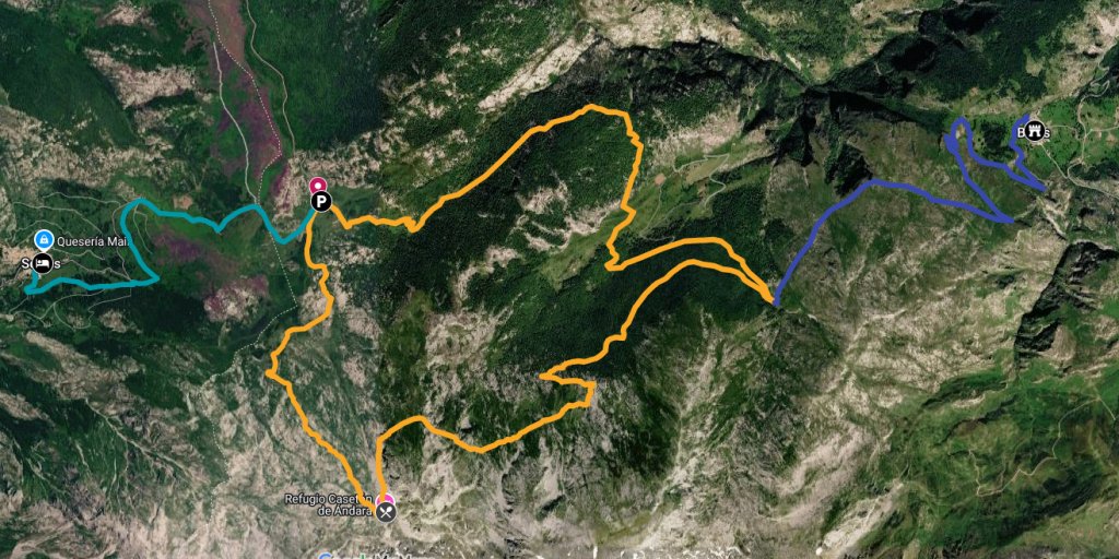
Route summary
The Ándara Massif route is a well-signposted circular walk that primarily follows clear livestock tracks and historic mining trails. While perfectly suited for anyone accustomed to hiking for several hours, the trail remains straightforward throughout, involving no exposed sections or technical difficulties.
| Distancie | 17 km/10.6 miles (Circular route from Jitu Escarandi) / 25 km/15.5 miles (extra distance to Bejes) |
| Type of route | Circular route |
| Difficulty | Easy to moderate, with no hazards or technical sections |
| Elevation gain | 735 m |
| Elevation loss | 735 m |
| Maximum altitude | 1.780 m |
| Minimum altitude | 1.090 m |
| Usual starting point | Jitu Escarandi, Cantabria. Google maps: maps.app.goo.gl/QnomEFEY |
| Nearby towns | Sotres (Asturias) and Bejes (Cantabria) |
| Best time of year | Late spring, summer and autumn |
| Estimated time | 5,5 hours |
| Official route | PR-PNPE 28 |
How to get there and where to park
The most common starting point is the Jitu de Escarandi car park. Situated at an altitude of 1,315 meters, it offers plenty of space to park before heading out onto the trail.
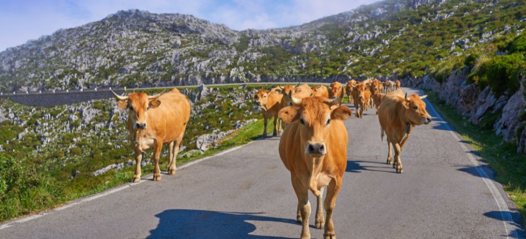
To get there, take the AS-264 road from Arenas de Cabrales toward Tielve and Sotres. Once you pass Sotres, the road flattens out; shortly after crossing the border from Asturias into Cantabria, you will see the car park on your right. Keep an eye out for cows along the way - they own the road and will take their time moving out of your path.
If you are staying in Sotres or Bejes - the two nearest villages - and are traveling without a car, you can reach the trailhead by walking an additional 6 to 8 kilometers (3.7 to 5 miles). You can trace the connecting path between the two villages on the map above.
The route step by step
The trail is officially signposted as the PR-PNPE 28 (a designated hiking route within the Picos de Europa National Park), making it straightforward to navigate with clear markers along the way. It is exceptionally easy to follow, as the path remains on a wide, well-defined track primarily used by local livestock farmers and the wardens of the Ándara refuge.
From Jitu Escarandi to the Casetón de Ándara Mountain Refuge
The trail begins right next to the information board in the Jitu Escarandi car park. The first 3 kilometers present the most demanding stretch of the hike, climbing steadily but manageably. The great news is that once you conquer this initial ascent, the remainder of the route is virtually all flat or downhill.
As you climb, the striking peak of Macondiú comes into view directly ahead, serving as your main landmark as you approach the refuge.
After a slightly gentler stretch, the trail passes Majada de Jazuca on the left, where you can see traditional stone shepherd huts. On your right is the entrance to a natural cave used for maturing the region's famous Picón cheese (lacasadelosquesos.com/picon-bejes-tresviso-dop).
From here, continue at a leisurely pace along the track, enjoying sweeping panoramic views all around until you arrive at the Casetón de Ándara refuge.
Arrival at the Casetón de Ándara
The refuge sits at an altitude of 1,725 meters.
It is easy to spot the Casetón from a distance, as the first things that catch your eye are an old railway carriage and a stretch of rusty tracks almost suspended in mid-air. These are some of the most striking remnants of the intensive mining activity that once defined the Ándara region.
Right next to the refuge, an outdoor fountain provides a perfect spot to refill your water bottle. You can also head inside to enjoy a refreshing drink at the bar or sit down for a hearty, hot meal.
Skirting Picu Macondiú
From the refuge, continue along the same main track, but keep a close eye out for a fork to the right that climbs up towards Picu Macondiú. While the main route continues to the left to skirt the mountain, you might want to take this detour to summit the peak.
Climbing Macondiú involves no dangerous exposure and is relatively short, but the trail is not particularly obvious. It follows a faintly marked path that can be easy to lose in places, requiring steady concentration and the occasional need to backtrack if you veer off course.
If you stick to the main track, once you have skirted halfway around Macondiú, you will reach a fork next to a stone wall and a signpost. Take the path to the left to begin your descent, knowing that the most demanding sections of the trek are now safely behind you.
Towards the beech forest
The track descends steadily from here. The views throughout this section are exceptionally wide-open, and on clear, bright days, you can even catch a glimpse of the sea shimmering in the distance.
Halfway down the descent, the trail opens up into a small, quiet pasture, where you will often spot horses grazing freely. Shortly after passing this meadow, the first lush beech forest of the day comes into view ahead.
The beech forest
The trail passes through two wooded areas of beech trees that offer excellent shade, making them the perfect spots to take a break, especially on hot summer days. If you look closely, you will notice the trees are relatively young - likely planted to reforest the mountainside following the closure of the local mines.
In autumn, these woods come alive with a beautiful display of vibrant leaves. In winter, the landscape completely transforms, allowing you to see right through the bare, striking branches to the mountains beyond.
La Fuente de los Lobos (the Fountain of the Wolves)
After briefly leaving the woodland, you will reach the Fuente de los Lobos, where the main track splits and descends toward the village of Bejes, some 9 km/5.6 miles away.
Our route through the Ándara Massif continues along the track to the left, following the signpost as it leads you back into the cool shade of the beech forest.
The second beech forest and return to Jitu Escarandi
During this final stretch through the woodland, you will pass turn-offs leading to several traditional sheepfolds, including those at Cerezal and La Llama. It is well worth taking a quick detour to these sites to get a closer look at the historic stone huts where shepherds lived during the summer grazing seasons.
From there, the trail brings you almost back to Jitu Escarandi. One last, short uphill effort is required before the car park where you began the day's journey finally comes back into view.
Which way round should you do the route?
Most walkers setting off from Jitu Escarandi tackle the climb up to the Casetón de Ándara first, saving the forest for the end. This is an excellent choice in the summer if you start early, as it allows you to get the longest ascent out of the way right at the beginning and enjoy the cool shade of the beech woods during the warmer, final hours of the trek.
The only downside to this direction is that you will reach the refuge quite early in the hike, whereas many walkers prefer to timing their break at the bar toward the very end of their journey.
Practical information
Recommended equipment
- Sturdy hiking boots or trail running shoes with excellent grip.
- Sun protection (hat, sunglasses, and sunscreen), as the route is highly exposed except for the shaded sections in the beech woods.
- Plenty of water, especially during warm weather. While you will pass natural springs along the trail, the water is untreated and not officially tested for safety.
- Warm layers, even in mid-summer. The route reaches altitudes above 1,500 meters, where mountain weather can shift quickly and turn quite chilly.
Could there be snow?
Yes. Throughout the winter and for much of the spring, it is common to encounter snow across the entire route, which can completely obscure the trail. While the terrain here is not particularly dangerous due to the lack of exposed drops or steep cliffs, carrying a GPS with the route pre-loaded is highly recommended if snow is likely.
Are there any animals roaming freely?
Yes. You will frequently encounter cattle and horses grazing freely at various points along the route. It is best to give them plenty of space and avoid disturbing them. In almost all cases, the animals will simply go about their business, as they are well-accustomed to sharing the mountain trails with hikers.
Frequently Asked Questions
Is this route suitable for beginners?
Yes, provided you have a reasonable level of fitness to comfortably cover the roughly 17-kilometer distance.
Are there any exposed or dangerous sections?
No. The entire main route follows well-defined, clearly marked tracks and does not feature any exposed ledges or areas with a risk of falling.
Is it suitable for children?
It largely depends on their walking experience. The complete absence of technical terrain makes this one of the most accessible circuits in the Picos de Europa, though the full 16-kilometer distance remains a significant undertaking for younger legs. For families, walking from Jitu Escarandi to the refuge and back is an excellent, shorter alternative (7 km / 4.35 miles round trip).
When is the best time to visit?
The route is best enjoyed from late spring through autumn. If visiting on hot summer days, plan ahead and bring extra hydration, as the trail offers very little shade outside of the wooded areas.
Can the route be extended?
Yes. From Fuente de los Lobos, you can follow the descending track all the way down to the village of Bejes, or extend your trip from Jitu Escarandi over to Sotres. Both traditional villages offer excellent local restaurants and overnight accommodation.






Contact
-
Edificio Sovega bajo, Crta General s/n
33554 Arenas de Cabrales
Asturias , Spaininfo@s-capetravel.eu
+34 (0) 985 846 455
UK call free 0800 707 44 35 -





Opening hours: Mon-Fri 9:00am – 6:00pm (CET)
Opening hours: Mon-Fri 9:00am – 6:00pm (CET)