


Hiking Route to Tresviso via the Urdón Gorge
A step-by-step guide to one of the Picos de Europa's most dramatic - and most rewarding - walks.
Tresviso: a remote village worth the climb
Perched at around 900 metres above sea level on the Cantabrian edge of the Picos de Europa National Park, Tresviso is one of the most isolated villages in northern Spain. It has no direct road access from Cantabria - the only road in comes from Asturias, crossing the Picos via Sotres, a drive of around an hour from Arenas de Cabrales. That isolation is the point.
For most visitors, the approach on foot via the Urdón Gorge is not just the most practical way to arrive - it's the right way. The path follows a route originally cut into the cliffside in the second half of the 19th century by miners extracting zinc ore from the Ándara and Tresviso mines. It is, in the most literal sense, an engineering achievement: hand-built stone retaining walls on near-vertical terrain, 790 metres above the river below.
The reward at the top is threefold: views over the eastern Picos massif that few visitors ever see, the village itself with its deep pastoral character - and Picón Bejes-Tresviso, one of Spain's finest PDO-protected blue cheeses, produced here since long before it had a name.
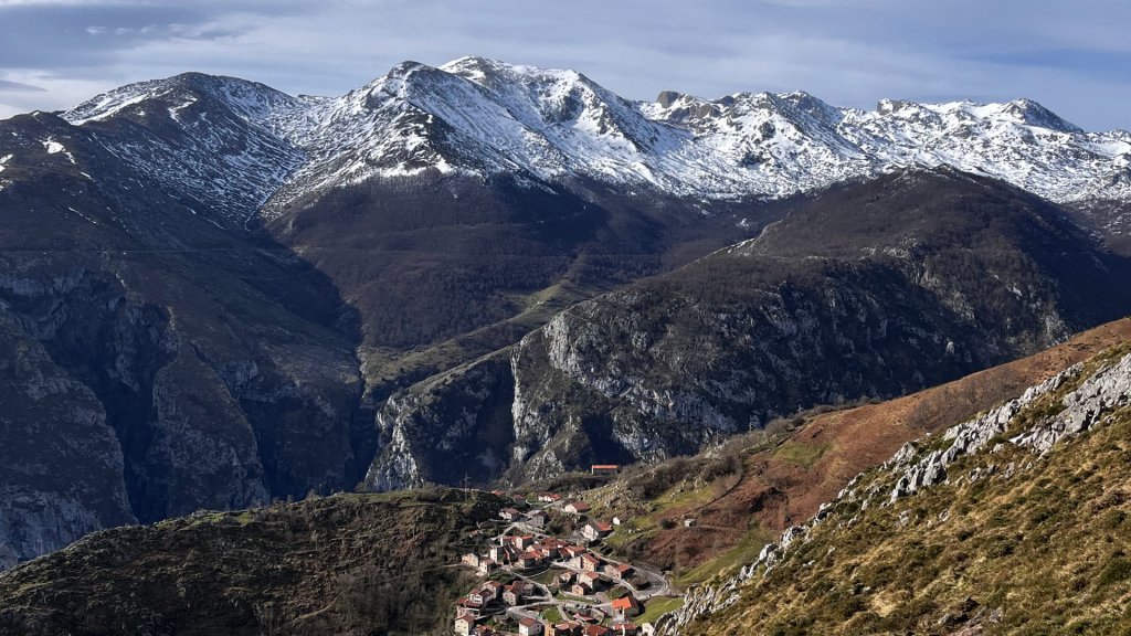
The hamlet of Tresviso under the Picos de Europa
Route overview - at a glance
| Distance (one way) | Approx. 6 km / 3.7 miles |
| Total ascent | 790 m / 2,590 ft |
| Altitude of Tresviso | Approx. 900 m / 2,950 ft |
| Estimated time | 2.5–3 hours (one way); 5–6 hours return |
| Difficulty | Moderate - sustained ascent on rocky terrain |
| Official route | PR-PNPE 30 (Urdón–Tresviso) |
| Start point | Urdón hydroelectric station, N-621 (La Hermida Gorge) |
| Navigation | Clear and well-marked; GPS not essential but recommended |
| Best season | Spring and autumn; manageable in early summer if you start early |
| Avoid | Hot weather and heavy rain - long exposed sections, slippery rock when wet |
| Nearest towns | La Hermida (2 km), Potes (approx. 25 km), Panes (approx. 12 km) |
| GPS track | PR-PNPE 30 - download here |
Note on route designation: the path is listed in the official Picos de Europa National Park trail network as PR-PNPE 30 (https://www.miteco.gob.es/es/parques-nacionales-oapn/red-parques-nacionales/parques-nacionales/picos-europa/guia-visitante/urdon-tresviso.html). There have been reports of waymarking being removed from parts of the path. The route itself remains passable and clear - but carry the GPS track and be aware you may see fewer trail markers than you'd expect on a signposted route.
Getting to the trailhead
The starting point is on the N-621 between Panes and Potes - the road that runs through the La Hermida Gorge, one of the most impressive limestone ravines in Cantabria. From outside of Spain, this road is not well-known; from inside the Picos it's a familiar artery. The drive south from Panes to La Hermida takes around 15 minutes.
At the point where the road crosses the Río Urdón, you'll find the hydroelectric station and the start of the trail, marked by an information panel. Parking is limited - a small layby that fills quickly in summer. An early start (before 9am in July and August) is strongly recommended if you want to park here.
Alternative: park in La Hermida village, 2 km further along the N-621 towards Potes, and walk an old riverside path back to the trailhead. This adds around 30 minutes to your day but solves the parking problem entirely. La Hermida itself has accommodation - the Balneario de La Hermida (https://balneariolahermida.com), a spa hotel built around natural thermal springs, is the most notable option.
Note: Do not confuse this route with the Canal de Urdón path - a separate, more technical route that follows the water channel down to the hydroelectric station. The canal path is unmarked and significantly more exposed than the PR-PNPE 30 described here.
The ascent: section by section
The approach along the Río Urdón (0–1 km): flat start, good warm-up
The route begins on a broad path that follows the river north from the information panel, passing the hydroelectric station within the first few minutes.
From here you can already spot the Cuetu Ave power station higher up the slope - and on days when the canal above is releasing excess water, you may see a waterfall falling down the cliff face.
Cross the first bridge, then a second shortly after. The landscape here is lush: willows, laurels, hazels along the riverbank, with figs and wild cherries clinging to the rock above.
The zigzags - Senda de La Peña (1–4 km): the sustained climb
After the second bridge, the path crosses to the right bank and the climbing begins in earnest. This section - known locally as the Senda de La Peña - is the historical miners' route, and you can see why it required such engineering.
The path zigzags up the cliff face in a series of tight switchbacks called ‘tornos’, with hand-built stone walls holding the track against the slope.
The path is unmistakable - there are no junctions or alternatives. Simply follow it upwards. Midway up, the route crosses back to the other side of the slope through a livestock gate.
- If the gate is open when you arrive, leave it open - livestock are grazing on both sides
- If it's closed, pass through and close it behind you
Shortly after the gate, a short section of path runs close to a vertical drop. It is brief - around 50 metres - and not technically difficult, but if you are uneasy with exposure, keep to the right-hand side and don't look down. The views from here over the Urdón basin and the peaks of the eastern Picos massif are extraordinary.
Balcón de Pilatos viewpoint: the essential stop
Around the halfway mark, the path arrives at the Balcón de Pilatos - a natural viewpoint with a low stone wall on the cliff edge. This is the place to stop, breathe, and take it in.
Looking down: the forested slopes of the Sierra de Bejes and the line of the Urdón water channel cut into the rock far below. Looking up: the jagged limestone peaks of the Ándara massif, the same mountains that the miners were heading into when they built this path.
A note on conditions: the terrain throughout this section is rocky and can be slippery in two distinct ways. In wet weather, the stone becomes smooth and treacherous. In very dry, hot conditions, loose surface stones roll underfoot on the descent. Take care in both.
Invernales de Pría: water, shade, and a natural rest stop
Once past the main zigzag section, the gradient eases noticeably. The path opens out and scattered trees - oak, beech - begin to provide patches of shade. The next landmark is the spring and seasonal shepherds' huts at the Invernales de Pría: a reliable water source and a natural place to rest before the final push.
The word ‘invernales’ refers to the low-altitude winter pastures - the huts here were used by herders moving their animals between the high summer pastures and the valley floor as the seasons changed. This transhumant - migratory seasonal livestock farming - tradition is still alive in the eastern Picos.
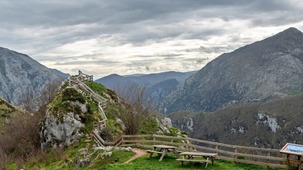
Viewpoint near Tresviso hamlet
Final approach and viewpoint detour
From the Invernales de Pría, the path continues at a gentler angle, the rocky track gradually giving way to a broader farm track. Shortly before the village, a short detour to the right leads to a second viewpoint - worth the five minutes if the weather is clear. The final stretch into Tresviso involves one last short climb before the path becomes a paved lane at the village entrance.
.png)
The village of Tresviso entering from Urdón path
Arrival in Tresviso
Arriving in Tresviso on foot is one of those experiences that really earns the effort you have to put in to reach it. The village is small - a few dozen permanent residents - and feels entirely untouched by the tourism that fills the valleys below. Stone houses, grazing cattle in the surrounding meadows, and almost no sound beyond the wind and the cowbells.
The road you'll see at the village entrance comes from Asturias via Sotres - for most of Tresviso's history, there was no road at all. A tarmac route was finally completed in 1990. Before that, the path you've just walked was the primary link between the village and the outside world.
Picón Bejes-Tresviso: the cheese that defines the village
Tresviso is inseparable from its cheese. Picón Bejes-Tresviso is a PDO-protected blue cheese made from a mixture of cow's, sheep's and goat's milk, matured for a minimum of two months in the natural limestone caves of the Liébana area. Its protection as a Denominación de Origen dates to 1994 (EU registration 1996 - https://www.foodswinesfromspain.com/en/food/products/cheese/picon-bejes-tresviso-pdo), under which production is restricted to a defined zone covering Tresviso, Bejes, and several municipalities of the Liébana valley.
The flavour is bold and distinctive: intensely savoury, with a piquant, slightly salty character that reflects the mineral quality of the high-altitude pastures. It is comparable to Cabrales - the better-known blue cheese from across the Asturian border - but has its own character, shaped by the specific caves and pastures of the eastern Picos.
In Tresviso, the only working producer is Quesería Javier Campo, who’s been making Picón here for decades, following a recipe passed down from his mother. The quesería offers cheese tastings and producer visits (https://www.quesodetresviso.com) - a genuinely memorable add-on to the route if arranged in advance. If a visit isn't possible, the cheese is available to buy and is sold in the village bar.
Eating and drinking in Tresviso
The village has at least two bar-restaurants (La Taberna and El Redondal serving food and drinks - more than you might expect in a settlement this remote. It's worth planning your timing around a meal here: a plate of Picón with local bread, eaten at altitude with a view over the peaks, is the natural conclusion to the climb. Check opening hours before your visit, particularly outside the main summer season.
Return options
Option A: return the same way - descent via the Senda de La Peña
The most straightforward return is back down the route you came up. The descent requires more attention than the ascent - the loose surface stones that were manageable on the way up become a slip risk going down, particularly when tired. Trekking poles are especially useful on the descent. Allow 2–2.5 hours.
Option B: road return via Sotres - requires planning
From Tresviso, the only road out goes via the CA-1 mountain road through Sotres and down to Arenas de Cabrales on the Asturian side. This is approximately 60 km and takes around 1 hour 30 minutes to drive - significantly further than it sounds. The road itself is a narrow, winding mountain road requiring care, particularly on the descent from Sotres.
This option requires either two vehicles (leaving one at Urdón and one at Arenas de Cabrales before the walk) or a taxi arranged in advance from Tresviso or Sotres. Do not assume you can arrange transport spontaneously in the village - plan ahead.
Practical information
Conditions and timing
Hot weather: not recommended if temperatures exceed 25°C. The lower section of the route is largely exposed with minimal shade, and the rocky terrain becomes slippery when very dry. If you're walking in summer, start as early as possible - before 8am ideally - to complete the ascent before the heat builds.
Rain: avoid in wet conditions unless you have mountain experience. The stone path drains well but becomes extremely slippery when wet. The gorge below can also become noisy and disorienting in heavy rain.
Best months: May, June (early start), September, and October. The spring wildflowers on the upper section and the autumn colours in the beech groves near the Invernales de Pría are both excellent reasons to choose these shoulder months.
Footwear and kit
Walking boots are essential - not trail runners. The rocky surface requires ankle support and a sole with grip. Trekking poles are recommended, particularly for the descent. Carry at least 1.5 litres of water per person; you can refill at the Invernales de Pría spring. A windproof layer is useful on the upper section even in summer.
Livestock and dogs
The route passes through active grazing land. Goats, sheep, and cattle are common, often accompanied by large Mastín Español (Spanish mastiff) sheepdogs. These dogs are not dangerous if approached calmly - slow down, give the animals space, and keep any dogs you have brought on a lead. Do not run or shout near the livestock.
Suitability
The route is suitable for adults and teenagers with previous hiking experience and a reasonable level of fitness. The sustained ascent (790 metres) makes this a genuinely demanding day for anyone unaccustomed to mountain walking. It’s not suitable for young children or those with a significant fear of heights. The brief exposed section below the Balcón de Pilatos is manageable for most people, but should be noted.
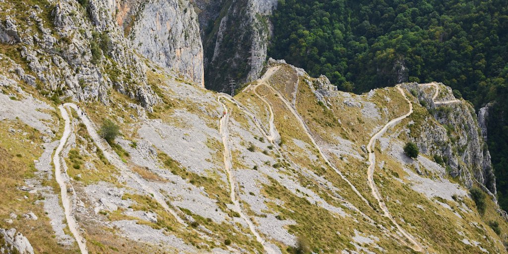
The zig-zag path from Urdón to Tresviso
Summary
This is a moderate route by Picos de Europa hiking standards - demanding primarily because of the sustained ascent rather than any technical difficulty. The path is clear and well-trodden, which allows you to give your full attention to the landscape rather than navigation.
What you get in return: one of the most historically layered walking routes in the eastern Picos, built by miners a century and a half ago and still used today; views over a part of the national park that most visitors never see; and arrival in a village where traditional mountain life - and one of Spain's finest blue cheeses - continues entirely on its own terms.
Getting to the region: the nearest airports are Santander (approx. 1h 45min), Bilbao (approx. 2h), and Asturias/Oviedo (approx. 1h 30min). A car is essential - public transport does not reach the Urdón trailhead. The drive from Santander follows the A-8 west, then the N-621 south through the La Hermida Gorge. Find out more about getting to the Picos de Europa.


Contact
-
Edificio Sovega bajo, Crta General s/n
33554 Arenas de Cabrales
Asturias , Spaininfo@s-capetravel.eu
+34 (0) 985 846 455
UK call free 0800 707 44 35 -


Opening hours: Mon-Fri 9:00am – 6:00pm (CET)
Opening hours: Mon-Fri 9:00am – 6:00pm (CET)