


Best Places to Go Hiking in Europe this Summer
The best places to go hiking in Europe in summer fall into two broad camps: high-altitude mountain trails, freed from winter snow by June and at their most spectacular through August; and Atlantic-facing coastal and lowland routes, where sea breezes and cooler temperatures make summer walking genuinely comfortable.
Below are six of the best - across Spain, France, the Netherlands, and the UK - ranging from a Pyrenean hut-to-hut mountain trek to a medieval pilgrimage route through the green hills of Cantabria.
Camino Lebaniego - Cantabria, Northern Spain
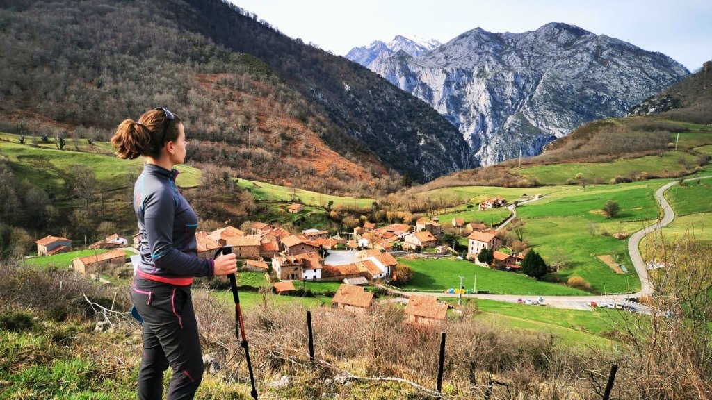
Cantabria in high summer is one of the most quietly spectacular corners of Northern Spain. While the southern costas sizzle and the Meseta shimmers, the northern coast stays green - cooled by Atlantic air and backed by the jagged limestone wall of the Picos de Europa, whose highest peaks push above 2,600m.
The Camino Lebaniego - a medieval pilgrimage route through mountain countryside to the singular Monastery of Santo Toribio de Liébana - is one of the most rewarding walks in northern Spain, and one that remains, by some margin, less walked than it deserves.
The route runs from the coast at San Vicente de la Barquera - a handsome fishing town granted royal trading privileges by Alfonso VIII of Castile in 1210, alongside Santander, Laredo, and Castro Urdiales - southward through an authentically rural hinterland to the Liébana valley at the feet of the Picos.
The Monastery of Santo Toribio holds a unique religious status: one of only five sites in the world authorised to declare a Holy Year of its own, alongside Rome, Jerusalem, Santiago de Compostela, and Caravaca de la Cruz (https://www.tourspain.es/en/camino-lebaniego). Pilgrims traditionally come to venerate what’s claimed to be the largest surviving relic of the True Cross - the Lignum Crucis - brought here from Astorga in the 9th century to keep it safe from the advancing Moorish invasion. The Puerta del Perdón, the Door of Forgiveness, opens only on those years when the Feast of Santo Toribio (16 April) falls on a Sunday - the next occurrences are 2027 and 2034 (wikipedia.org/wiki/Santo_Toribio_Liebana).
The walking shifts gradually from coastal paths and riverside tracks in the first stages to increasingly remote mountain terrain as the route enters the Hermida Gorge and climbs towards Potes. The final section, from the medieval town of Potes to the monastery itself, ends with a 225m climb to a hillside setting from which, on clear days, the snow-capped peaks of the Picos are visible in every direction.
Recommended route: Puentenansa to Lebeña. The most dramatic stage of the S-cape itinerary drops you at the tiny, remote hamlet of Lafuente before a steep climb to the Collada de la Hoz pass (665m) with its first full views of the Picos limestone wall.
The route then traverses a genuinely remote rural hinterland - down to Cicera, up to the Arcedón pass (845m), and down again to Lebeña, where the pre-Romanesque church of Santa María, built in the Mozarabic style in the late 10th century, is one of the finest small churches in northern Spain (https://www.spain.info/church-santa-maria-lebena/).
Need to know: distance: 13 km; walking time: 5.5 hrs; ascent/descent: ↑750 m / ↓800 m; difficulty: moderate.
Average summer temperatures (Potes / Liébana valley)
- June: 19°C (low 12°C) / 66°F (low 52°F)
- July: 22°C (low 14°C) / 72°F (low 55°F)
- August: 22°C (low 14°C) / 72°F (low 55°F)
Insider tip: The S-Cape itinerary uses private transfers cleverly to skip the uninteresting road sections that make up the official Camino Lebaniego, meaning every kilometre you walk earns its place. An optional extra day in the Picos de Europa - taking the cable car at Fuente Dé (1,835m) and walking down through the high pastures of Áliva - is one of the finest mountain days in northern Spain.
The Pieterpad - The Netherlands
Most people who hit the road in the Netherlands in summer are looking to explore it on two wheels. The Pieterpad makes an equally strong case for doing so on foot.
The Pieterpad is the country's longest and most beloved long-distance trail, running 500km from the Wadden Sea coast at Pieterburen in Groningen to the Sint-Pietersberg hill near Maastricht - the trail's official southern terminus, with the city of Maastricht the practical end-point for most walkers.
The trail was conceived by Toos Goorhuis-Tjalsma from Tilburg and Bertje Jens from Groningen, who met as hiking companions and set out in the late 1970s to design a walking route between their cities. At the time, there were few established national long-distance walking routes in the Netherlands - both women had been travelling abroad to find trails worth walking.
The Pieterpad opened in 1983, and a monument to its two founders now stands at the halfway point in Vorden. Around 40,000 walkers complete one or more stages each year, making it by far the most popular long-distance hiking route in the Netherlands.
The stages through the province of Drenthe are a particular highlight in summer. The Drentsche Aa National Park carries walkers through dark pine forest, open heathland turning purple in late August (https://www.drentscheaa.nl/english).
The park is also home to clusters of hunebedden: megalithic burial chambers built between 3400 and 3000 BC by the Funnel Beaker Culture (www.holland.com/hunebedden). Several of these dolmen groups sit directly alongside the Pieterpad, including two of the finest examples in the country near Rolde - requiring no detour to visit.
Recommended route: The S-cape itinerary covers the northern half - 14 stages from Pieterburen to Vorden, through three distinct provinces - and in summer it reveals a side of the Netherlands that most visitors never see: vast skyscapes over polder farmland, ancient woodland estates, and a landscape that carries plenty of fascinating prehistory.
One of the most inviting stretches runs from Zuidlaren to Rolde/Anderen. A classic Drenthe stage through the Balloërveld heathland, past ancient burial mounds, and across part of the Hondsrug - a UNESCO Global Geopark ridge formed in the penultimate ice age, running from Groningen to Coevorden (www.unesco.org/hondsrug-unesco-global-geopark). The stage ends in Rolde, within easy reach of the most celebrated dolmen cluster on the whole route.
Need to know: distance: 17.5 km; walking time: 4.5–5.5 hrs; ascent/descent: minimal (flat to gently rolling terrain); difficulty: easy.
Average summer temperatures (Drenthe)
- June: 19°C (low 10°C) / 66°F (low 50°F)
- July: 22°C (low 13°C) / 72°F (low 55°F)
- August: 22°C (low 13°C) / 72°F (low 55°F)
The Pieterpad is exceptionally well served by Dutch public transport (www.ns.nl/en) - nearly every stage start and end point is accessible by bus or train, making it possible to walk individual stages from a single base without a car. The S-Cape itinerary runs all year round, though June and July offer the best combination of long days and dry weather.
Midi d'Ossau - French Pyrenees
The Pic du Midi d'Ossau is not the highest summit in the Pyrenees - at 2,884m it sits well below the Vignemale and Aneto - but it is unquestionably the most dramatic.
A twin-towered plug of solidified magma that rises abruptly from the Ossau Valley with no foothills to obscure its flanks, it’s long been called the Matterhorn of the Pyrenees. It’s a peak so distinctive in outline that it once appeared on Béarnais coins, and serves today as the unofficial emblem of the western range.
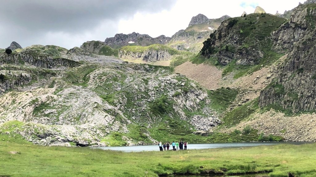
From the high cols around it, on a clear day, you look down on a landscape of glacier-carved lakes and high pastures that appears unchanged since the last ice age.
Wildlife at this altitude is abundant and close. Chamois pick their way across scree slopes with complete indifference to walkers; marmots whistle from boulder fields; and the cols above Pombie are regularly circled by griffon vultures. On rarer occasions, you can also spot lammergeiers, the bearded vultures reintroduced to the Pyrenees and other parts of Europe in the 1990s after more than a century of local extinction (https://beardedvulture.ch/project).
This trek is open from mid-May to October, but mid-summer - when the high passes are clear of snow and the days are longest - is the prime window.
Recommended route: The S-Cape 5-day mini-trek is no easy saunter. It’s a genuine mountain adventure - three nights split between mountain refuges, with all personal kit carried, no luggage transfers, and two nights in bunkbeds above the treeline.
The circuit begins at the Col du Pourtalet on the French-Spanish border and loops around the base of the Pic over three days via the Refuge de Pombie and the Refuge d'Ayous - two of the most celebrated mountain huts in the Pyrenees. The Refuge d'Ayous in particular is famous for its position above the Lac de Gentau: at sunrise, the Pic du Midi rises directly behind the peak's eastern face, and the reflection in the lake below it is one of the most photographed mountain images in France.
One of the most memorable stages runs from the Refuge de Pombie to Refuge d'Ayous. The central stage of the circuit, climbing from the Pombie hut through rough, barren mountain scenery to the Col de Suzon (2,131m) before descending to the Lac de Bious, then climbing again to the celebrated Ayous hut above its chain of alpine lakes.
Need to know: distance: 13 km; walking time: 6 hrs; ascent/descent: ↑700 m / ↓700 m; difficulty: challenging. No luggage transfer - all kit carried throughout.
Average summer temperatures (Laruns / Ossau Valley base)
- June: 20°C (low 11°C) / 68°F (low 52°F)
- July: 24°C (low 13°C) / 75°F (low 55°F)
- August: 24°C (low 13°C) / 75°F (low 55°F)
Insider tip: Both mountain refuges, Refuge de Pombie (https://refugedepombie.ffcam.fr) and Refuge d'Ayous (www.refuge-ayous.fr), serve dinner and breakfast - booking well in advance is essential in July and August. Bring a sleep sheet, pillowcase, and towel; these are not provided. The bus to Col du Pourtalet runs only in July and August; outside these months, a car is required.
Land’s End - Cornwall, UK
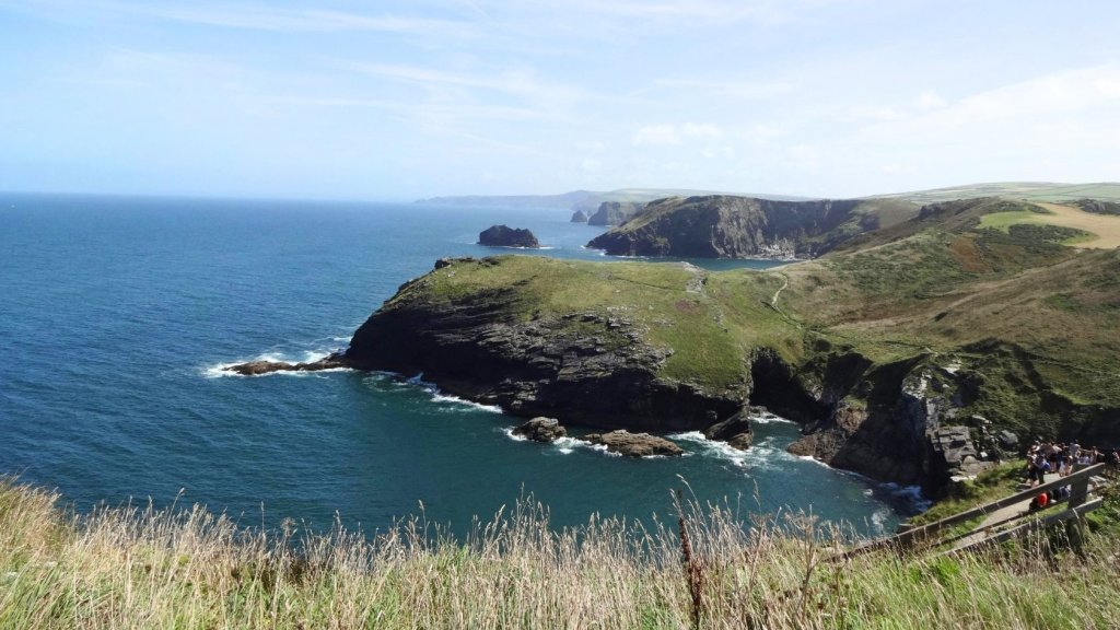
Land's End is dramatic by name, and dramatic by nature. The peninsula - the section of the South West Coast Path running from St Ives to Penzance - is 62km of some of the most technically demanding and spectacular coastal walking in Britain.
The route involves constant ascent and descent over headlands, past fishing villages, ruined engine houses of the tin-mining industry and around the most westerly point on the English mainland.
What makes this stretch exceptional for summer walking is a quirk of Cornwall's Atlantic-facing geography. The peninsula juts west into the prevailing sea wind, keeping temperatures moderate even at the height of summer - typically cooler than inland Britain - while the trail's constant exposure means there’s almost always a breeze on the clifftops.
The area's industrial heritage is protected by UNESCO, as part of the Cornwall and West Devon Mining Landscape World Heritage Site (whc.unesco.org/en/list/1215). Within this site, the Crowns engine houses at Botallack are two ruined buildings perched directly above the Atlantic surf at the base of the cliffs and connected to a mine that once extended a kilometre out under the seabed (https://www.nationaltrust.org.uk/visit/cornwall/botallack/explore-botallack).
Cape Cornwall is a quietly interesting geographical footnote: until accurate surveys were completed, it was believed to be the most westerly point in England - a distinction that ultimately belonged to Land's End, a few kilometres further south (en.wikipedia.org/Cape_Cornwall). The cape's pointed headland, topped with a disused mine chimney, remains far less visited than Land's End and considerably more atmospheric.
Recommended route: St Ives to Zennor. The opening stage, and perhaps the slowest 10km on the entire South West Coast Path: a relentless boulder-hop along clifftop paths above the Carracks, home to a colony of grey Atlantic seals visible from the trail, and above Pendour Cove - before a final steep climb inland to the ancient granite village of Zennor, with its quaint church, small museum of Cornish life, and the Tinners' Arms (https://tinnersarms.com), one of the most satisfying pubs in Cornwall to arrive at after a hard day's walking.
Need to know: distance: 10 km; walking time: 3.5–5 hrs (the boulder terrain makes this highly variable); ascent/descent: approx. ↑↓ 400–500 m; difficulty: challenging (rough, rocky, occasionally boggy terrain - ankle support essential).
Average summer temperatures (Penzance / Land's End peninsula)
- June: 16°C (low 12°C) / 61°F (low 54°F)
- July: 18°C (low 14°C) / 64°F (low 57°F)
- August: 18°C (low 14°C) / 64°F (low 57°F)
Need to know: The S-cape itinerary covers St Ives to Penzance over 6 walking days with luggage transferred between all accommodation. The shortest day is the final stroll from Mousehole to Penzance (6.4 km) - a gentle finish that gives time to explore Newlyn's galleries or Penzance's peculiar Egyptian House (www.landmarktrust.org.uk/egyptian-house) before departure.
The Auvergne, France
Le Puy-en-Velay is one of the oldest pilgrimage departure points in the Christian world. In 951 AD, Bishop Gothescalk of Le Puy is recorded as one of the first foreign pilgrims to reach Santiago de Compostela.
In the process, he made Le Puy the oldest documented starting point for the journey - and the Via Podiensis, the GR 65, the route from which all others followed (https://en.wikipedia.org/wiki/Via_Podiensis).
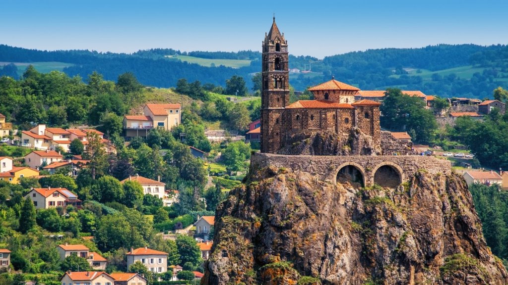
The city itself sits in a landscape unlike almost anywhere else in Europe: a ring of ancient volcanic plugs erupting from the valley floor of the Haute-Loire, each topped with a monument or chapel. The most vertiginous is the Rocher Saint-Michel, an 80m basalt needle carrying an 11th-century Romanesque chapel on its summit - accessed by 268 carved steps cut directly into the rock face (en.lepuyenvelay-tourisme.fr/le-rocher-saint-michel).
The first section of the GR 65 - Le Puy to Aumont-Aubrac - is widely considered the finest walking introduction to rural France available. The route climbs from the cathedral steps at 625m onto the vast Velay plateau, crosses the wild gorge of the Allier river at Monistrol, then ascends the Margeride - a high granite plateau.
It’s also a place with a particular hold on French imagination. This was the territory of the legendary Beast of Gévaudan in the 1760s (https://en.wikipedia.org/Beast_of_Gevaudan): a wolf-like creature that killed over a hundred people across three years and was never conclusively identified, inspiring two centuries of debate between those who believed it was a large wolf, a hyena, or something else entirely. The town of Saugues, a day's walk into the Margeride, has a museum dedicated to the Beast in its medieval English Tower (www.musee-bete-gevaudan.com).
The route ends at Aumont-Aubrac, gateway to the high Aubrac plateau - a vast, windswept volcanic upland above 1,000m. It’s also a place that maintains ancient transhumance traditions: the annual movement of cattle herds to high summer pastures, accompanied by the sound of cowbells that can be heard across the plateau for hours (www.tourisme-en-aubrac.com/entranshumance).
Recommended route: Le Puy-en-Velay to Saint-Privat d'Allier. The opening stage, departing from the cathedral steps and climbing from 625m to 966m across the vast Velay plateau - lentil fields, basalt-walled farms, and wide views back towards the volcanic plugs of Le Puy - before descending to the pretty fortified village of Saint-Privat, perched above the Allier gorge.
Need to know: distance: 23 km; walking time: 5–6 hrs; ascent/descent: ↑573 m / ↓390 m; difficulty: moderate.
Average summer temperatures (Le Puy-en-Velay)
- June: 20°C (low 11°C) / 68°F (low 52°F)
- July: 23°C (low 13°C) / 73°F (low 55°F)
- August: 23°C (low 13°C) / 73°F (low 55°F)
Insider tip: Le Puy-en-Velay is at its most atmospheric in the early morning, when the pilgrim registration office in the cathedral crypt opens and the first walkers of the day gather at the steps before departure.
Arriving the evening before and attending the early-morning pilgrims' mass in the cathedral - held at 7am in season - is worth doing even for non-religious travellers: it’s a genuine piece of living medieval tradition, and the departure of the first walkers from the cathedral steps at dawn is a special moment.
Cumbria & North Yorkshire, UK
When Alfred Wainwright devised the Coast to Coast Walk in 1973 - without official backing, published only as a personal guide with hand-drawn maps - he couldn’t possibly have imagined that it would eventually be walked by hundreds of thousands of people and become a formal National Trail.
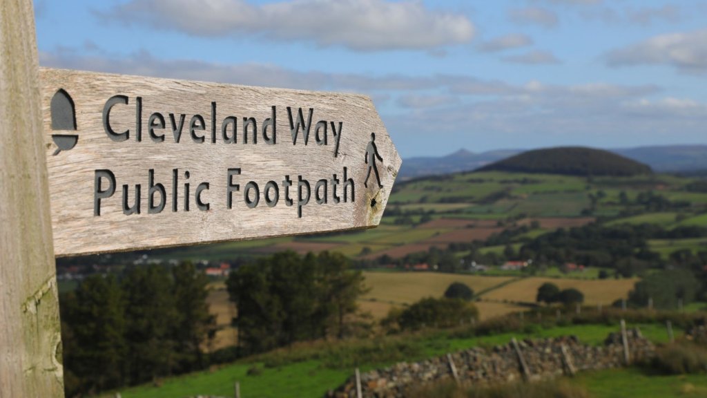
The Wainwright Trail was formally designated a National Trail in August 2022 (en.wikipedia.org/Coast_to_Coast_Walk). It joined the Pennine Way and Cleveland Way as one of the great waymarked walking routes in England - with a multi-year programme of path improvements and waymarking largely completed by 2025.
The full walk runs 350 kilometres / 190 miles from the Irish Sea at St Bees to the North Sea at Robin Hood's Bay, crossing three National Parks. The eastern section - from Kirkby Stephen in Cumbria to Robin Hood's Bay in North Yorkshire - is considered by many seasoned walkers to be the more varied and rewarding half.
The terrain shifts constantly. In Kirkby Stephen - a handsome market town in the Eden Valley, the parish church houses a remarkable Viking-era cross-shaft fragment carved with a bound figure identified as Loki, the Norse god of mischief. It’s a fascinating relic of the region's Scandinavian past preserved inside a Christian building (https://www.ksparishchurch.com/loki-stone).
The route crosses the Pennines and drops into Swaledale, one of the most beautiful valleys in England: tight-walled, flower-filled meadows in June, ancient stone barns at every field boundary, and the River Swale running clear below.
A crossing of the Vale of Mowbray - flat, fertile, and easy - bridges the transition to the North York Moors, 33km of high moorland traversed along the track of an abandoned mine railway, ending at the Lion Inn at Blakey Ridge. This 16th-century former hunting lodge sits at the highest point of the North York Moors, one of the most remote pubs in England, and the only building for miles in any direction (http://lionblakey.co.uk).
The final stage, from Grosmont to Robin Hood's Bay, ends with a clifftop walk above Jurassic cliffs before the descent into the cobbled streets of the bay itself - where, by long tradition, the walker dips their boots in the North Sea and deposits the pebble collected at St Bees on the first day.
Recommended route: Keld to Reeth. The first walking stage of the S-cape itinerary offers a choice of routes: the high-level crossing through the remote grouse moorland and lead-mine ruins above Swaledale, or the lower riverside path through heather-clad dale with traditional stone barns and drystone walls at every turn. Both arrive in Reeth - a quintessential Dales village with a broad green and several very good pubs - and both showcase the Yorkshire Dales at their summer best.
Need to know: distance: 19 km; walking time: 5–6 hrs; ascent/descent: ↑420 m / ↓550 m; difficulty: moderate.
Average summer temperatures (Yorkshire Dales / North York Moors)
- June: 17°C (low 9°C) / 63°F (low 48°F)
- July: 19°C (low 11°C) / 66°F (low 52°F)
- August: 19°C (low 11°C) / 66°F (low 52°F)
Need to know: The S-cape itinerary runs April to September. Between Keld and Reeth, seasonal route variants apply to reduce erosion on high moorland - summer walkers can take the high-level option, which is both the more spectacular and the more historically interesting, passing extensive lead-mining remains from the 18th and 19th centuries (www.yorkshiredales.org.uk/lead-mining-in-swaledale).
Summer Hiking FAQs
When’s the best time to go hiking in Europe in summer? June and early July offer the best combination of longer days, lower visitor numbers, and wildflowers at peak. Late July and August tend to be a little busier and hotter at lower elevations, but at altitude - in the Pyrenees especially - conditions remain excellent. The Pieterpad and French Camino are pleasant throughout the summer months.
Which European destination is best for summer hiking if I want to avoid extreme heat? The Atlantic coast of northern Spain (Camino Lebaniego), the Netherlands (Pieterpad), and both UK destinations - Cornwall and Yorkshire - benefit from Atlantic and maritime influence that keeps summer temperatures moderate, typically between 17–22°C even in July and August. The Pyrenees and French Massif Central are warmer at lower elevations but cool rapidly with altitude.
Do I need previous hiking experience for these routes? The Pieterpad (Netherlands) and the GR 65 Le Puy section (France) are well-suited to walkers with limited experience, provided they’re comfortable covering 15–23km per day over five to six consecutive days. The Camino Lebaniego, Cornwall Coast Path, and Coast to Coast all require reasonable base fitness and some experience with uneven terrain. The Pic du Midi d'Ossau trek is for experienced mountain walkers: there are no luggage transfers, all kit is carried, and two nights are spent in mountain refuge dormitories above 1,900m.
Are these routes suitable as self-guided walks? All six are offered by S-cape as self-guided itineraries, with accommodation pre-booked, luggage transferred between stages (where applicable), and detailed route notes and GUIBO app navigation included. No guide is required.
How far in advance should I book a summer walking holiday? For July and August, accommodation fills quickly on all six routes - particularly the Camino Lebaniego and the Coast to Coast, where village accommodation can be limited. Booking three to six months ahead is strongly recommended. The Pyrenees mountain refuges should be reserved as early as possible for summer dates.
Can I walk just part of a route? Yes. The Pieterpad in particular is designed to be walked in sections - every stage start and end point is accessible by public transport. The GR 65 Le Puy section and the Coast to Coast can also be joined at intermediate points.


Contact
-
Edificio Sovega bajo, Crta General s/n
33554 Arenas de Cabrales
Asturias , Spaininfo@s-capetravel.eu
+34 (0) 985 846 455
UK call free 0800 707 44 35 -


Opening hours: Mon-Fri 9:00am – 6:00pm (CET)
Opening hours: Mon-Fri 9:00am – 6:00pm (CET)