Five Unmissable Walking Routes on La Palma
The Canary Islands, as any keen walker knows, isn’t short of a good hike or two. Even by those high standards, though, La Palma stands out.
As is the case across the archipelago, La Isla Bonita’s agreeable year-round weather is a major part of its appeal - particularly if you’re looking for a walking break during the autumn/winter months.
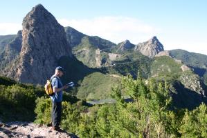
The scenery is spectacular and surprisingly varied - as you might expect from the fact that the whole of La Palma is a UNESCO-protected Biosphere Reserve (Unesco.org), and it’s one of the highest islands in the world relative to its size.
Paths wind their way along dramatic crater rims, through whispering cloud forests, down to quiet farmland and rugged coasts. It’s a fair bit wetter - and consequently greener - than some of the other islands, too.
But perhaps the main feather in its cap is the sheer number of well-marked trails - +1,000km at the last count - that crisscross the relatively small island. We’ve picked out just a few of those in our roundup of the best walking routes on La Palma.
Pico Bejenado Circular Loop
Views are rarely in short supply on La Palma. But this loop to Pico Bejenado (1,854 m) offers one of the best 360-degree viewpoints on the western side of the island, with sweeping vistas across the Caldera de Taburiente, the Aridane Valley, and out to sea.
The ascent begins in the pine forests of La Cumbrecita and winds gently up to the summit. It’s a great choice if you’re wanting caldera views without committing to the full ridge route - and perfect to catch that trip-defining shot of the soft light and sea mist.
Need to know: difficulty: moderate; distance: 9.5 km; time: 4 hrs; ascent/descent: ↑↓ 750 m.
El Tablado to Gallegos
This rugged northern coast trail between El Tablado and Gallegos showcases the island’s wildest Atlantic-facing scenery. The path threads between deep ravines, terraced slopes, and coastal cliffs, passing small farmsteads and native vegetation zones.
It’s a remote-feeling walk with little in the way of infrastructure, so you’ll need to organise a transfer or return along the same route. The lack of crowds and the raw, elemental landscapes make it an ideal option for experienced hikers seeking a quieter side of the island.
Need to know: difficulty: moderate to challenging; distance: 8.4 km; time: 4.5 hrs (one way); ascent/descent: ↑ 450 m / ↓ 750 m.
Los Franceses & the Dragon Trees of the North
This wild and lesser-trodden route through Los Franceses, in La Palma’s remote north, offers a rugged contrast to the island’s (slightly) busier southern side.
Steep ascents and descents define the terrain, but the rewards are rich: dramatic ravines, lush vegetation, and a scattering of ancient dragon trees (Dracaena draco) clinging to the hillside.
You’ll follow narrow paths carved into deep barrancos, with panoramic views of the white crests of the Atlantic waves rolling in and a tangible sense of isolation throughout.
The diversity of plant life and untamed character of this part of the island make it ideal if you’re looking for a hiking trail that mixes beauty and solitude.
Need to know: difficulty: challenging; distance: 7.5 km (one way); time: 3.5–4 hrs; ascent/Descent: ↑ 650 m / ↓ 500 m.
Pico de la Nieve to Reventón Pass
This high-altitude route skirts the caldera rim, starting at Pico de la Nieve (2,239 m) and heading southeast toward Reventón Pass. It features epic ridgeline views over both sides of the island and takes in some of the most atmospheric sections of the GR 131 long-distance path (Caminosnaturales.es).
The descent toward Reventón winds its way down through pine forests, making it a rewarding downhill finish - keep an eye out for Canary Island Chaffinches, Red-billed Choughs, and furtive Dark-tailed Laurel Pigeons (AKA Bolle's pigeons) as you go along.
Need to know: difficulty: moderate; distance: 11.5 km (point to point); time: 4.5–5 hrs; ascent/descent: ↑ 320 m / ↓ 780 m.
Ruta de los Volcanes
Stretching along the island’s volcanic backbone from the Refugio El Pilar to Los Canarios in Fuencaliente, the Ruta de los Volcanes is one of La Palma’s most iconic hiking trails.
The route traces a dramatic ridge through a surreal landscape of lava fields, craters, pine forests, and ash-covered slopes. It passes the craters of San Juan and Hoyo Negro, skirting the more recent flows of the 2021 Cumbre Vieja eruption (Wikipedia.org).
The latter stages are home to some lovely, natural pools on the beach - perfect for a cooling dip at the end of a long, hot day. Then to cap it all off, there’s an attraction of the gastronomic variety waiting for you right at the end of the trail: the Michelin-starred El Jardin de la Sal restaurant (Salinasdefuencaliente.es).
Need to know: difficulty: moderate to challenging; distance: 17.5 km (linear); time: 6–7 hrs; ascent/descent: ↑ 500 m / ↓ 1,200 m
Like our pick of the best walking routes on La Palma? Have a look at our self-guided walking tour.
La Palma in pictures
Marketing, Web & Design
After studying in my hometown of Barcelona and spending several years abroad, I relocated in 2018 to Cabrales, a beautiful rural area in Northern Spain. I invite you to check out some photos of Cabrales to see the incredible views we enjoy from our office!
After a few years in reservations, I now manage the website and marketing for S-Cape Travel, where I handle design tasks, blog writing, and attend specialized travel fairs.


Opening hours: Mon-Fri 9:00am – 6:00pm (CET)
Opening hours: Mon-Fri 9:00am – 6:00pm (CET)