


Guide to cycling the Camino del Norte
Cycling the Camino del Norte is a spectacular experience: it combines coastline with beaches and cliffs, forests, modern towns and rural villages. But it requires physical training. In this blog you can see the distances and climbs of the different stages and find out how to prepare for it.
As for the route, it is usual to alternate sections of the official route with secondary roads. At some points, while cycling on the road, you will see yellow arrows indicating detours to dirt tracks. Our advice: evaluate each detour carefully before following the arrows. Sometimes these sections rejoin the same road further down the road, without adding much to the experience and sometimes adding unnecessary gradients to your day.
History of the Camino del Norte
The Camino del Norte emerged as a safe route in the High Middle Ages, promoted by King Alfonso II and used by pilgrims from northern Europe to avoid the conflicts in the south of the peninsula. Asturian and Castilian monarchs promoted the construction of monasteries and hospitals, many of which still exist today. Nowadays it is the third most popular pilgrimage route, valued for its mild climate and its proximity to the sea.
Location
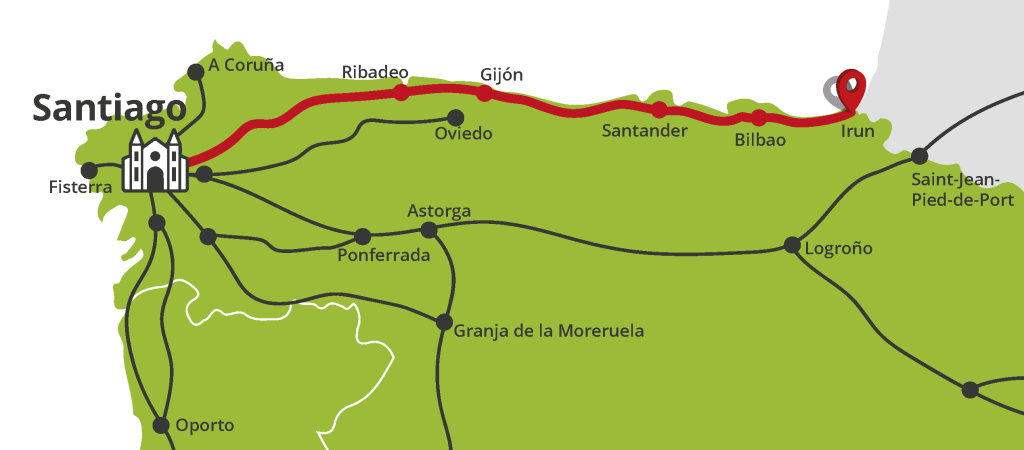
The Camino del Norte follows the Atlantic coast, crossing the provinces of the Basque Country (Euskadi), Cantabria and Asturias. It is when you reach Galicia that you head inland, looking for the most direct route to Santiago.
Along the Way, you will pass through cosmopolitan cities such as Bilbao, San Sebastián (Donostia), Santander, Gijón or Avilés, and a host of fishing villages and rural hamlets such as Zumaia, Llanes, Ribadeo, Markina-Xemein, Baamonde or As Cruces. When you take a break in the middle of the stage, take the opportunity to try some local cuisine.
Map of the Camino del Norte by bike
Starting and finishing points
The most common starting points are Irun - a town in the Basque Country bordering France - or Donosti/San Sebastián or Bilbao, which are more accessible by public transport and have better options for renting a bike.
The Camino del Norte ends in Santiago de Compostela, more precisely, in the Plaza del Obradoiro.
Difficulty and stages
The Camino del Norte by bike is not an easy ride; although, it is a popular and well-equipped route - with plenty of accommodation and services for pilgrims - the truth is that the ‘official’ stages are of medium to medium-high difficulty.
The daily average is around 45-55 km (28-34 miles), with climbs of between 800 and 1,200 metres and other gentler but not less than 400m. The good news is that, thanks to the abundant infrastructure, you can adjust the stages according to your pace and experience.
Let's look at the most common stages among cyclists, where the route combines sections of the Camino (which is shared with pilgrims on foot) with sections on secondary roads.
Stages of the Camino del Norte by bike
- Stage 1: Irún - Zarautz. 46km/28.5 miles (+1.207m)
- Stage 2: Zarautz - Markina 45km/28 miles (+1.083m)
- Stage 3: Markina - Bilbao 58km/36 miles (+1.348m)
- Stage 4: Bilbao - Castro Urdiales 41km/25 miles (+750m)
- Stage 5: Castro Urdiales - Laredo 33km/20.5 miles (+825m)
- Stage 6: Laredo - Santander 56km/35 miles (+850m)
- Stage 7: Santander - Santillana del Mar 47km/29 miles (+725m)
- Stage 8: Santillana del Mar - Colombres 50km/31 mies (+960m)
- Stage 9: Colombres - Ribadesella 54km/34 miles (+1.030m)
- Stage 10: Ribadesella - Villaviciosa 20km/12 miles (+1.200m, up and down)
- Stage 11: Villaviciosa - Oviedo 43km/27 miles (+990m) or Gijón 29km/18 miles (+840m)
- Stage 12: Oviedo 30km/18.5 miles (+400) or Gijón - Avilés 32km/20 miles (+310m)
- Stage 13: Avilés - Cudillero 32km/20 miles (+575m)
- Stage 14: Cudillero - Luarca 55km/34 miles (+680m)
- Stage 15: Luarca - Ribadeo 55km/34 miles (+325m)
- Stage 16: Ribadeo - Mondoñedo 38km/23.5 miles (+975m)
- Stage 17: Mondoñedo - Sobrado dos Monxes 52km/32 miles (+635m)
- Stage 18: Sobrado dos Monxes - Santiago de Compostela 56km/35 miles (+625m)
The Camino del Norte in images


The weather and the best time to cycle
In terms of temperatures, the Camino del Norte can be done between April and October, including the summer months. In July and August, there can be some hot days, but the nights are usually pleasant and if you leave early in the morning, you will enjoy the cool air.
Be aware that the wettest periods are during spring and autumn, especially if you choose to follow the official Camino, where you may encounter mud on unpaved tracks. You can always avoid these sections by taking the road.
How to get there
By train
Major cities such as Paris, Madrid or Barcelona offer direct train connections to Hendaye (FR) and/or Irun (ES), Bilbao or San Sebastian. You can consult the website of Renfe (Spain) or SNCF (France). Between towns, you can use the narrow-gauge train Euskotren, formerly known as Feve.
By bus
The boom in bus companies with international routes connects Irún and the cities of the Basque Country with the rest of Spain and Europe. The largest companies are ALSA, FlixBus, Ouibus, etc...
By plane
The nearest airports are Donosti/San Sebastián and Bilbao, the latter with more international flights. From both airports there are good train or bus connections to Irun or the city centres.
Ferry from the UK
If you plan to travel by ferry from Britain, especially if you come with your bike, there is a direct connection between Plymouth and Santander or Portsmouth and Bilbao.
By car to Bilbao
Bilbao is well-connected by road from anywhere in northern Spain:
- From Madrid or the south: via the A-1 and then the AP-68 (toll).
- From Santander or the west coast: Via the A-8 (Autovía del Cantábrico), which runs along the entire northern coast.
- From Vitoria-Gasteiz: On the N-622 and then the AP-68, quick and direct.
- In the metropolitan area there are several car parks if you do not want to drive into the city centre. Some private parking options also offer long stays for pilgrims.
By car to Irun
Irun is located right on the border with France and is also a strategic crossing point:
- From France: Direct access via the A63 (France) which becomes the AP-8 when crossing the border.
- From San Sebastian or Bilbao: The AP-8 connects the entire Basque coast.
- From inland (Pamplona): The N-121-A crosses the western Pyrenees and leads directly to Irún.
- Irún has free parking options on the outskirts and paying areas closer to the centre or the station.
Five unmissable places to visit
- Markina-Xemein (Basque Country), an authentic Basque village with a deep-rooted local culture. When you arrive in the village, enter the San Miguel de Arretxinaga Chapel, a chapel with a curious hexagonal base, built around 3 dolmens.
- Donosti/San Sebastián, a must-visit city to stroll around the town centre, and to have some pintxos for dinner - It sounds simple, but it is not easy to choose between so many delicious pintxos!
- Santillana del Mar: a picture-postcard village in Cantabria. If you happen to be there, spend the night wandering the cobbled streets during the evening.
- The Atlantic beaches: although the Camino del Norte runs parallel to the coast, it is not always right next to it. We recommend Gulpiyuri, between Llanes and Ribadesella (Asturias), a special beach as it is sunken, in the middle of a meadow.
- Visit the impressive monastery in Sobrado dos Monxe, founded in 951.
Can you get the Compostela by bike?
Yes. You will have to cycle 200km/124 miles before arriving in Santiago and stamp your pilgrim's credential at least twice a day. Once in Santiago, go to the International Pilgrim Centre for the Compostela.
Tips for cyclists
- With several unpaved sections, choose an MTB or gravel bike with a good gear and grippy tyres if you are going to follow the official Camino.
- If you are not hiring a travel agency to help you with the logistics and you are going to carry your luggage, distribute the weight well between the panniers,
- Before you leave, we advise you to pack everything you need for your journey, and go 45-55 km (28-34 miles) bike ride. Then after the ride, re-evaluate whether you can take less items on your pilgrimage.
- We are talking about the north of Spain, so it is sure to rain occasionally. Take a waterproof jacket or poncho that covers your whole body and waterproof panniers. It is also advisable to store your belongings in dry bags just in case you get really unlucky with the weather and your panniers are not as waterproof as you had hoped.
- In some rural areas it is not easy to find a bike workshop, so you should carry at least a basic puncture repair kit, a pump and a spare inner tube. You should also be aware, most, if not all, shops are closed on Sunday.
- Book accommodation in advance if you are going in high season: the coast of the Basque Country, Cantabria and Asturias are hugely popular in summer. If you are staying in hostels, bear in mind that preference is given to pilgrims on foot; so, do not plan to arrive too early, but also reserve some energy in case you have to cycle a few extra kilometres to the next hostel.
- If you want to use your own bike, you can use the bicycle delivery service of Correos, Seur or Sendyourbike; or alternatively, travel by ferry on an overnight crossing.
Marketing, Web & Design
After studying in my hometown of Barcelona and spending several years abroad, I relocated in 2018 to Cabrales, a beautiful rural area in Northern Spain. I invite you to check out some photos of Cabrales to see the incredible views we enjoy from our office!
After a few years in reservations, I now manage the website and marketing for S-Cape Travel, where I handle design tasks, blog writing, and attend specialized travel fairs.
Most popular


Contact
-
Edificio Sovega bajo, Crta General s/n
33554 Arenas de Cabrales
Asturias , Spaininfo@s-capetravel.eu
+34 (0) 985 846 455
UK call free 0800 707 44 35 -


Opening hours: Mon-Fri 9:00am – 6:00pm (CET)
Opening hours: Mon-Fri 9:00am – 6:00pm (CET)