


Trip notes
We are proud of the accuracy and details of the material that we deliver to all our customers.
As a rule, we do NOT print documents anymore (for sustainability reasons) and we will give you access to our navigation app, which is very easy to use on any smartphone. However, if you prefer printed roadbooks and maps, we can deliver them to the first accommodation for a small extra fee. Please indicate this on your booking form.
The route descriptions
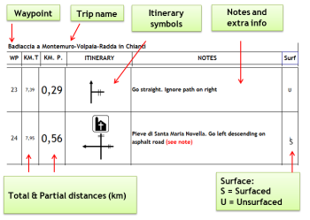
The route descriptions lead you from waypoint to waypoint (WP). A waypoint is a GPS (Global Positioning System) term for a marked spot on the earth. The itinerary tells you what to do at each waypoint and always gives a short description of what you will see in case there is any landmark, route sign or waymark.
Finding your way will be easiest if you always read a few lines ahead: Where is the next waypoint? How far is it to the next step on the route description?
Distances are always given in metres and kilometres. Distances are not measured in time, because each person has a different walking/cycling speed. As a general indication, we provide the estimated total walking/cycling time using a set time/distance ratio.
The maps
If you have booked and paid extra for receiving a printed copy of the route descriptions at the first accommodation, you might also receive a set of maps that have been created especially for this trip. Please notice that there re no maps created for all our trips.
Each map has a walking/cycling route marked on it in a distinctive colour. Extensions or detours / side excursions are marked in a different colour. There is only 1 route marked on each map. This is always a dotted red or brown line. Alternate routes or shorter variants are marked in other colours.
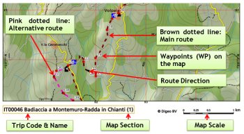
Waypoints are also printed on the map so that, even if you aren’t using a GPS receiver, you can easily find your position on the map and relate waypoints to the instructions given in the route description.
Navigation App
Besides the roadbook en eventual maps, you will also receive credentials to access the trip on a navigation app. At present, we are using our own ActiveNav app and Guibo. Both of this apps shows, besides the track, the daily information, so you can have it all on your mobile phone.
In case you prefer to use your own GPS device or app, you can ask as for the tracks.


Contact
-
Edificio Sovega bajo, Crta General s/n
33554 Arenas de Cabrales
Asturias , Spaininfo@s-capetravel.eu
+34 (0) 985 846 455
UK call free 0800 707 44 35 -


Opening hours: Mon-Fri 9:00am – 6:00pm (CET)